
Release Version 6.0.1 · Matt and Tom
Detector Maps 6.0.1: small number, big update
We meant 6.0.1 to be a small one. Then it grew. Our Detector Maps 6 post showed you the big picture. This is the rest of the story: what each Terrain+ detector looks for, tenement alerts for the ground you care about, a Community rebuilt from the ground up, Permissions that know their fields, and Trails that keep every step.
01Terrain+
Terrain+: what the detectors look for
Outline an area up to 4.8 km (3 miles) across and it opens in 3D. A slider raises or flattens the ground, so a low bank or a shallow pit stands out, and you can drape any map layer over it. Then the detectors go to work. Each one reads the shape of the ground and marks what it finds, so you start with a short list, not a whole hillside.

Gold detectors
- WorkingsFinds shafts, pits, costeans and mullock heaps, and counts them for you.
- DispersionShows where gold shed from those workings is likely to lie downhill.
- Trap SitesShows where flood gold drops out.
One model, one tap34 shafts, 71 prospecting pits, 114 mullock heaps.
Gold detectors, USA
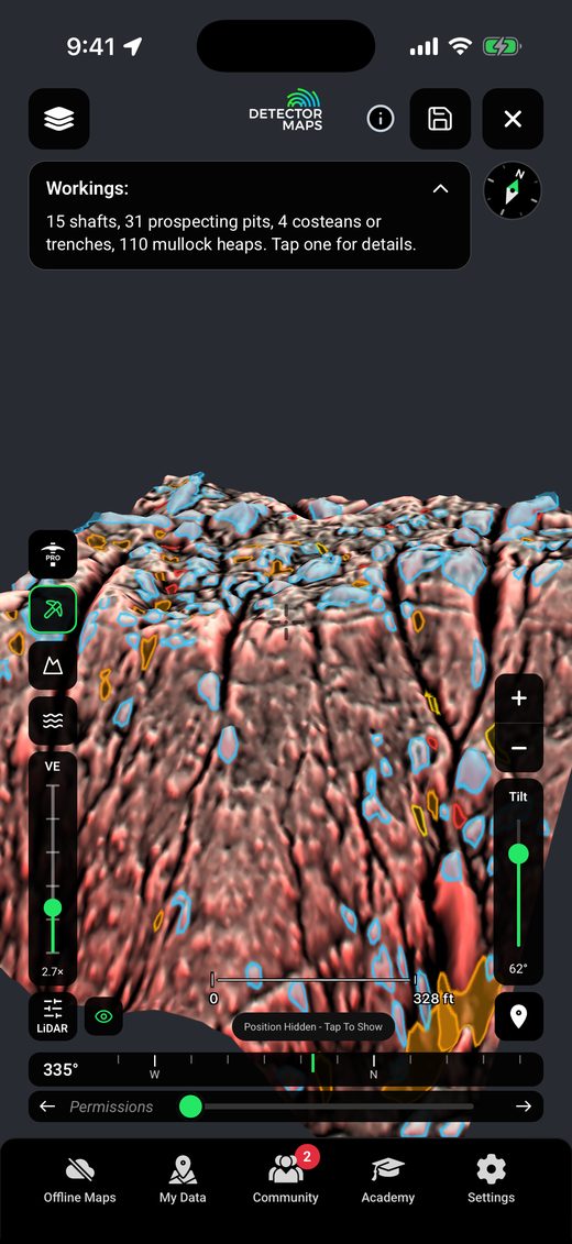
- WorkingsThe same detector on USGS lidar: shafts, prospecting pits, trenches and mullock heaps, counted.
- DispersionShows where gold shed from those workings is likely to lie downhill.
- Trap SitesShows where flood gold drops out.
One model, one tap15 shafts, 31 prospecting pits, 4 costeans or trenches, 110 mullock heaps.
England detectors
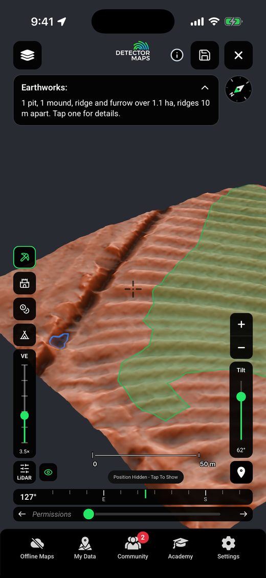
- EarthworksFinds pits, mounds, banks, ditches and ridge and furrow.
- Roman CampFinds the corners of Roman camps.
- Coin Hoard and SettlementShade the likeliest ground for a hoard or a settlement and mark the top three spots.
One model, one tap1 pit, 1 mound, ridge and furrow over 1.1 ha, ridges 10 m apart.
Where it works: NSW, Queensland and Tasmania with Explorer. Victoria with the LiDAR add-on. England and Scotland on any paid plan (the detectors are England only). The US gold states with Pro. Saved models open from the Terrain+ menu for 30 days, with no signal.
Want the tour of Dynamic LiDAR’s nine looks and how a model rises? It’s in Detector Maps 6.
02Tenement alerts
Know when the ground changes
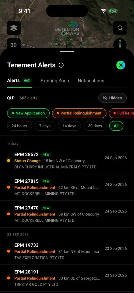
Ground opens up and closes all the time. Now you hear about it. Draw an outline around your patch, or watch your whole state, and Detector Maps tells you when a title there moves.
- Watch an areaDraw an outline, or watch all of your state. You hear when a title there is applied for, granted, ended or reduced, changes hands, or has its expiry changed.
- Behind the bellAlerts lists the changes at your watches. Expiring Soon lists titles running out in the next 7 to 90 days.
- A History tabTap a tenement and open History: the holder and since when, every change we have, and the reports found there.
- Tenement changes on the mapA row at the top of Mining Boundaries draws the last 90 days of changes, so new ground shows at a glance.
- Once a day, or as they comeAlerts arrive once a day. For every change, up to every 15 minutes, turn on As they come through in Settings.
Australia. Watch an area comes with Pro; Expiring Soon comes with Explorer. SA tenements are now named by their title number.
03Community
Community, rebuilt
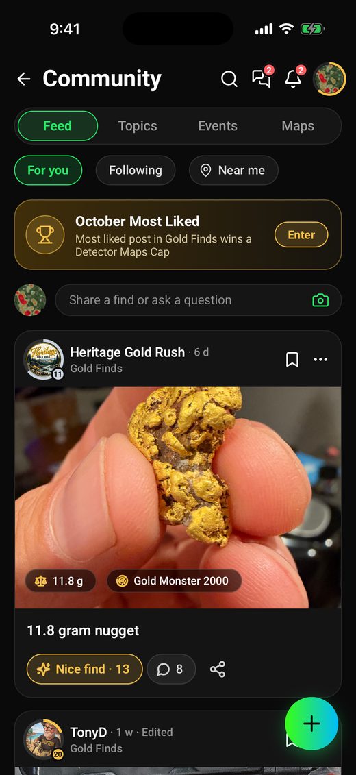
The best part of detecting is showing someone what came out of the ground. The new Community gives every find a proper stage, and gives you reasons to come back: levels to climb, badges to earn, and days out with people who hunt the way you do.
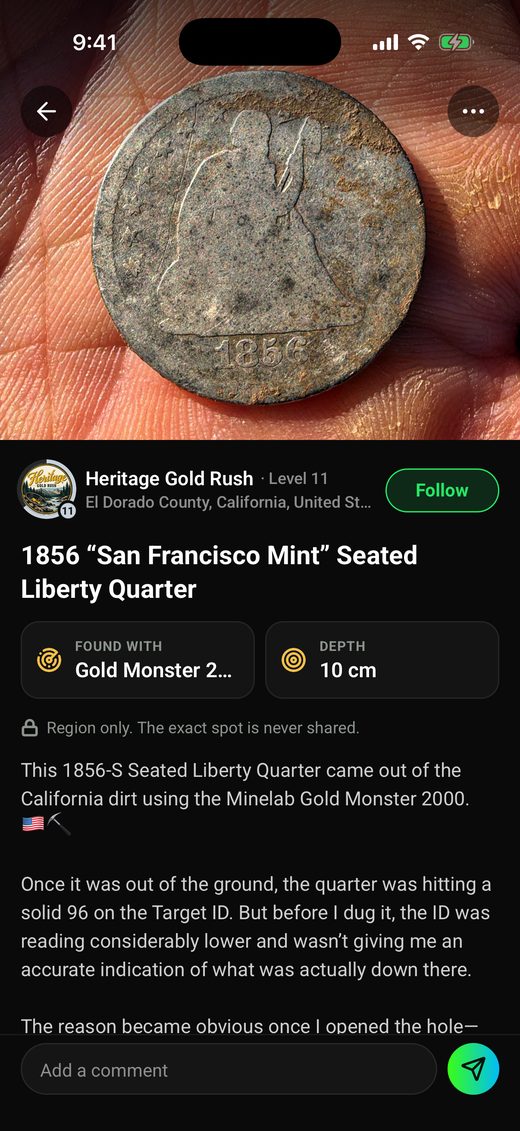
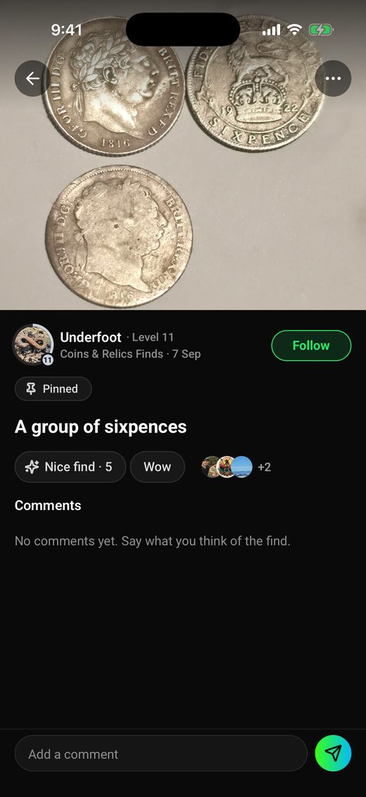
- Levels and XPEarn XP for posting finds, answering, recording Trails and saving waypoints, and climb 30 levels from Rookie to Legend.
- Badges and ringsFounder, Team and Staff badges show who runs the place. The ring round each photo shows that person’s level.
- EventsFind a detecting day, beginners’ morning, meetup or clean-up near you, or host one from Level 3. Everyone going gets a group chat.
- Reactions and answersReact to a find with Nice find or Wow. Mark the reply that solved your question as the answer, and its writer earns XP.
- Polls and find factsAsk the group with a poll. Add the weight, the depth and what you found it with to a find.
- Challenges and leaderboardsJoin challenges such as the monthly Most liked, and climb the leaderboards for the week, month or season.
Every region. Free accounts can read; taking part needs a paid plan.
04Coins & relics
Permissions, and the fields they sit in
Every relic hunter keeps a mental list of the farms they’re allowed on. Now the app keeps it for you, on the map, with the landowner’s number, where to park, the rules, and the field that was ploughed last week.

- Add to permissionsTap a land title or property on the map, then Add to permissions. In the US, the owner’s name and mailing address fill in for you.
- The landowner in one placeCall, text or email them from the permission. Keep where to park, the gates, the rules and a photo of the agreement with it.
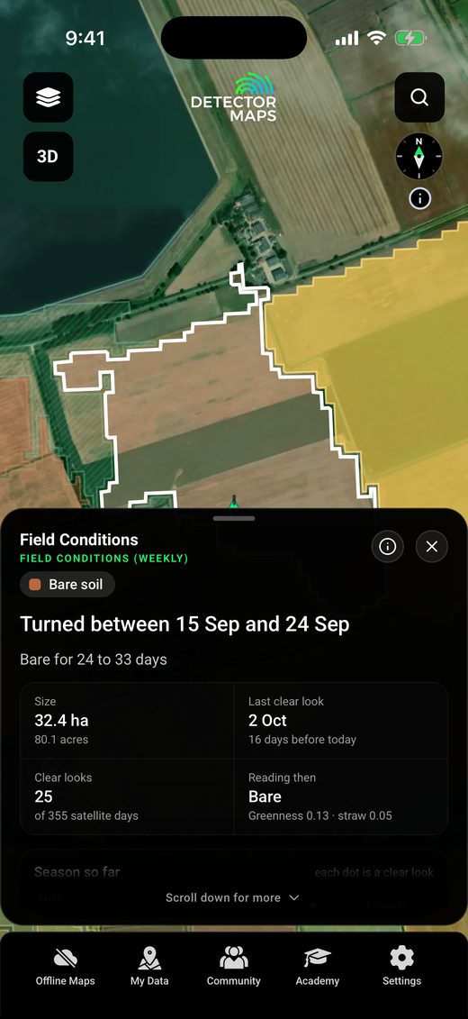
- Fields and your findsMark each field Ploughed, Stubble, Crop in, Grass and more, and see them coloured on the map. Finds and Trails on the land group under it.
- Share a permissionSend one or several to a friend as a pack file. They get their own copy to keep.
- Field ConditionsSee which fields are freshly turned, bare, in stubble or green this week, read from satellite. Press Play to watch the season go by.
- what3wordsThree word addresses in the coordinates, on pins and waypoints, in search and in the waypoint editor.
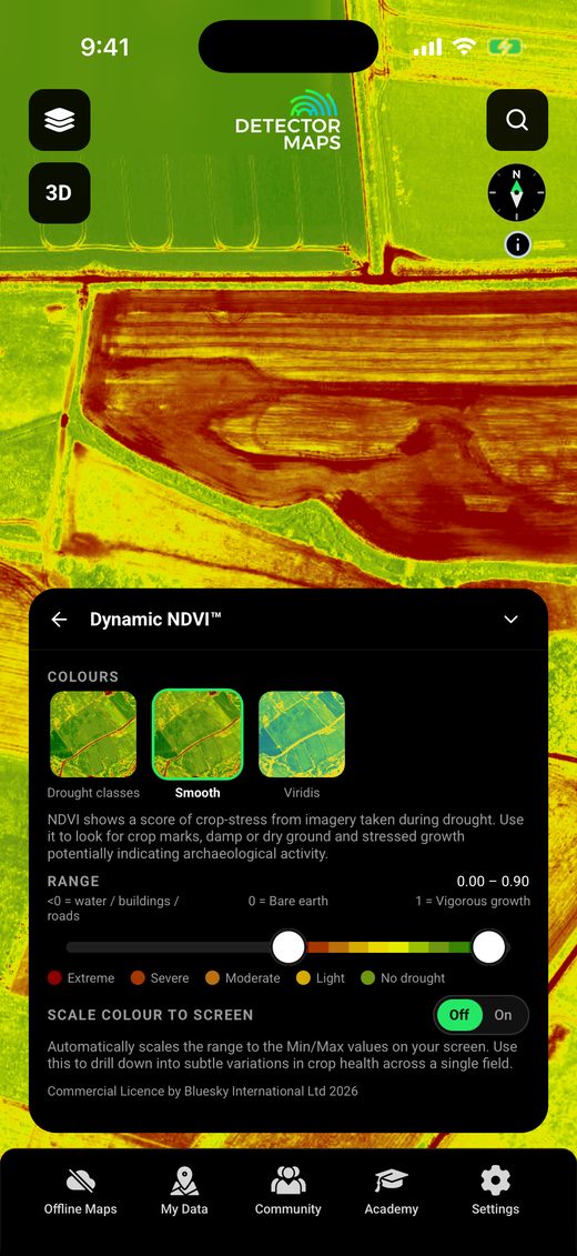
Permissions: the UK and coin & relic mode in the USA. Field Conditions and what3words: UK, with Field Conditions on the paid plans. Dynamic NDVI: an England add-on, +£50 a year.
05Trails & replays
A smoother map, even with all your tracks
We rebuilt how Breadcrumbs, Trails and Waypoints are drawn. They now use far less of your phone as you pan and zoom, so a map with a season of hunts on it feels as quick as an empty one.
- Breadcrumbs and Trails, rebuiltYour live trail is much lighter on the map, and recorded Trails draw smoothly even with thousands of points.
- Waypoints, rebuiltSaved pins put less strain on your phone, particularly when you have lots of them.
- Every point keptSaved Trails now draw every point you recorded, so slow search loops keep their shape.
- Replay videos, much fasterVideos are made frame by frame on the phone, with the map fully loaded in every frame. Size them for your phone (9:16), YouTube (16:9) or Instagram (1:1).
- A photo studioUp to six designs over your map, with your finds and their photos, ready for an Instagram Story.
- More files come inKMZ files from Google Earth and Avenza import, and Trilobite Trail CSVs come in as Trails.

Free on every plan, in every region.
06Around the map
Small things, every day
The little things you reach for on every trip, and a new way to sign in.
- Remove blocks from a saved areaOpen a saved offline area, tap Remove Block, then tap the blocks you no longer need.
- Open in MapsSend the middle of the map to Apple Maps or Google Maps, for the drive to the gate.
- The LiDAR Look cardPick a rendering from its picture, colour a grey one, set brightness and contrast, and save the looks you like.
- Google satellite in every regionChoose Google from the basemap tiles anywhere you detect, with Explorer.
- Layers that update themselvesMap layers now update without an app update, and a card tells you what changed.
- Toggle allOne switch in Active Layers hides your layers and brings them back exactly as they were.
- Pick your marker colourYour location arrow comes in green, cyan, orange or the new pink.
- Sign in with a codeEnter your email and we send a 6 digit code. Already have a password? It still works. New here? A Getting started tour and five short lessons are waiting.

07By region
What 6.0.1 brought where you detect
Australia
- Tenement alerts for an area you draw or a whole state (Pro), and a History tab on every tenement sheet.
- Terrain+ in Queensland, NSW, Victoria and Tasmania, with Workings, Dispersion and Trap Sites.
- Sharper LiDAR from zoom 14, and Premium LiDAR saves offline with your areas.
- SA tenements are named by their title number.
USA Gold
- New gold state maps, detailed state geology with a Gold host rocks only switch, and Alaska as a new gold state.
- Dynamic LiDAR replaces the old hillshades, and Terrain+ builds 3D models from USGS lidar. Both with Pro.
- Property boundaries from zoom 13, a Roads switch on the Washington map, and Explorer plans on Android.
USA Coins & Relics
- Land Permissions: landowner details, access notes, rules and photos of the agreement, with each field’s state and packs to share.
- Dynamic LiDAR with colours, brightness and contrast you set, and your saved looks. With Pro.
United Kingdom
- Field Conditions: every farm field read from satellite each week. Step back through the last year, and tap a field to see when it was turned.
- Land Permissions for the farms you detect, with what3words on the map, in search and on waypoints.
- Dynamic LiDAR in England, and in Scotland from its own lidar. Terrain+ in both, with Earthworks, Roman Camp, Coin Hoard and Settlement in England.
- Dynamic NDVI in England, with a slider to compare it with the map, and a Roads switch.
New Zealand
- A Roads switch on the map, plus everything in Community, Trails and Around the map above.
Canada (British Columbia)
- A Roads switch on the map, plus everything in Community, Trails and Around the map above.
08Fixes
Steadier, too
- Stays signed inYou stay signed in when reception is patchy as the app opens.
- CarPlay on iOS 26The app no longer closes as it opens after you have used CarPlay.
- PhotosFixed a crash when choosing a photo.
- SyncSync shows its progress and copes with large amounts of data.
- AndroidMore reliable Trail recording, a faster start, and Android 16 support.
Update from your app store
6.0.1 is a free update for everyone on Detector Maps. New here? Start free for 7 days on a yearly plan. Nothing is charged until it ends.
Start free for 7 daysiPhone · Android · Web
Next up: what's new in 6.1.