For coin and relic hunters in the USA

Find where the old town stood.

Free ghost towns. Free old topo maps. LiDAR for cellar holes and old roads on Pro. Plan at home, use it with no signal.

On iPhone? Get it on the App StoreOn Android? Get it on Google Play

Free to download on iPhone and Android.

7-day free trial on yearly plans · Nothing charged until it ends · Cancel anytime.

Scan with your phone camera to get the app
Start free trialOpen the web map

On your phone: App Store · Google Play

7-day free trial on yearly plans · Nothing charged until it ends · Cancel anytime.

4.7 / 5 from 2,400+ ratings on the App Store and Google Play · 10,000+ prospectors and detectorists
Dynamic LiDAR™ in USA coins and relics, drawn over satellite imageryDynamic LiDAR · Pro · Dana Common© Mapbox, © Maxar
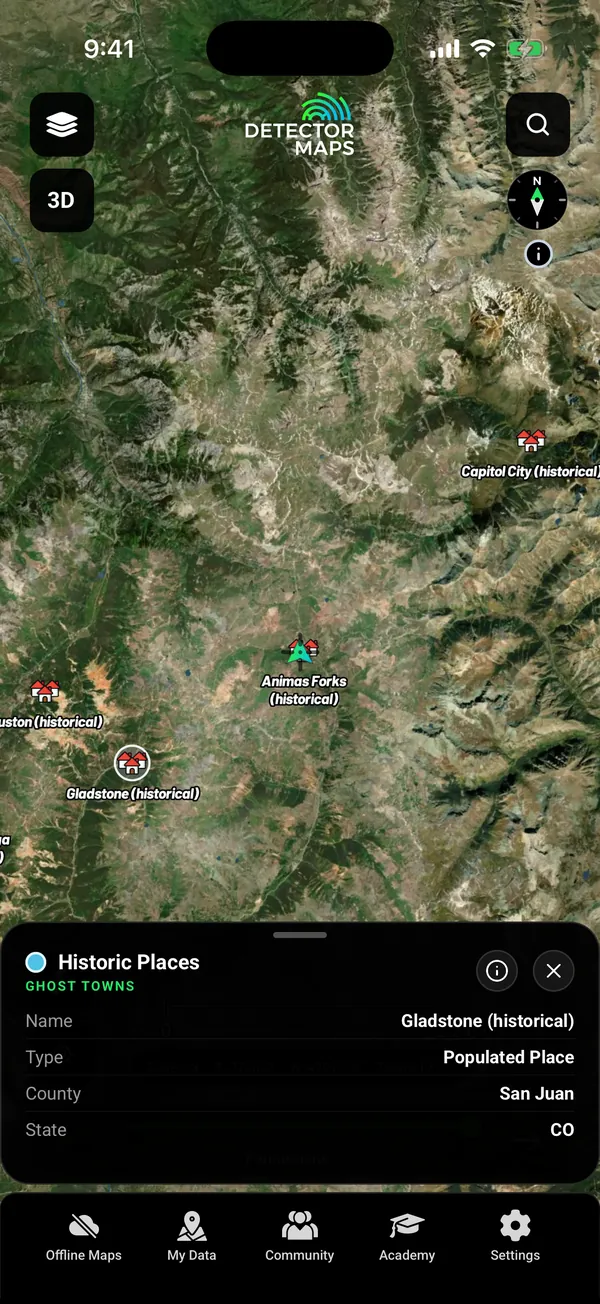
Ghost Towns in the San Juan Mountains of Colorado with a tapped record card (Gladstone, historical populated place)

Dynamic LiDAR over the old town of Dana, Massachusetts. Satellite imagery © Mapbox, © Maxar. Layer data from the sources named on each card.

4.7 / 5from 2,400+ ratings on the App Store and Google Play
10,000+prospectors and detectorists
Nationwideone map for coins and relics
Freeghost towns and old topo maps
Free first

Free on every plan, forever.

Start with the free layers. Pay only if the map earns it.

  • Ghost towns
  • Old USGS topo maps by era
  • One free area of 250 km², offline too
  • Trails, replay and backups
  • Waypoints, shapes and search

Inside your free area every layer works except LiDAR.

01The night before

Find the places people left.

Ghost towns are plotted on the map and free to open. Explorer adds homesteads, mills, river crossings and ferries, old schools and historic railroads.

  • Ghost Towns Free
  • Homesteads and plantations, mills, ferries, old schools, railroads Explorer
Ghost Towns in the San Juan Mountains of Colorado with a tapped record card (Gladstone, historical populated place)

Ghost Towns. Free.

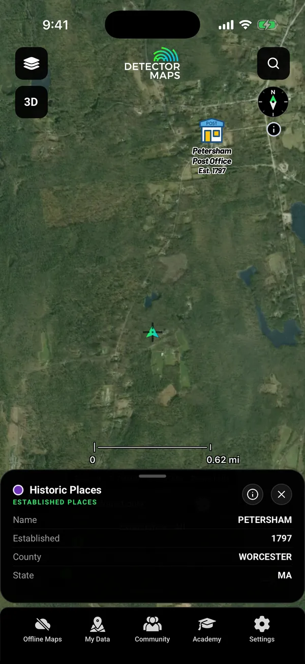
Historic Established Places on satellite near Petersham, Massachusetts: the Post Office icon labelled Est. 1797, with a tapped record card (Name Petersham, Established 1797, County Worcester, State MA) and the Abandoned only switch and Established slider (Established to All)

Historic Established Places. Explorer.

02Old maps

Lay the old map over the ground.

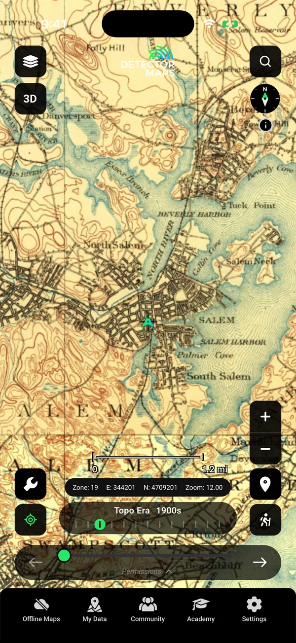
Pick an era and fade the old topo sheet over today’s map to see roads and buildings that are gone. Old maps can be stretched or offset, so treat what you see as clues.

  • Historic Topo by era Free
  • Historic mine locations from old USGS sheets Explorer
Historic USGS Topo (by era) over Salem, Massachusetts: a 1900s topographic sheet with the Topo Era slider

Topo Era 1900s. Fade it over today.

03See under the trees

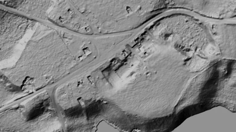
Cellar holes show in LiDAR.

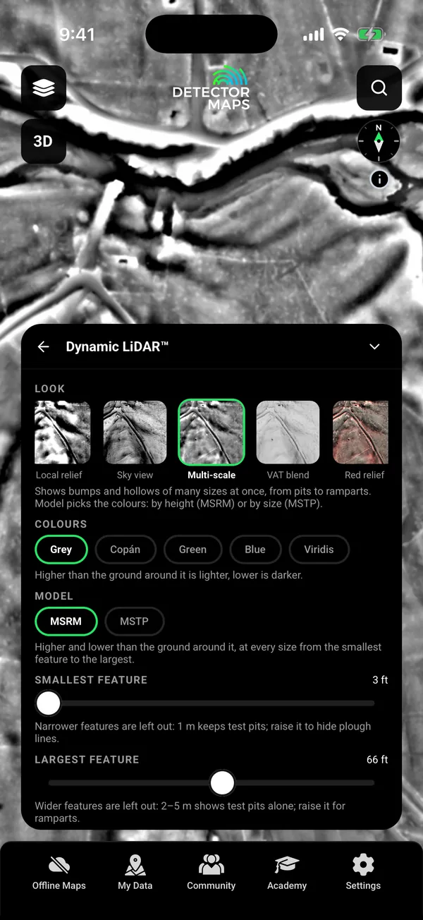
Dynamic LiDAR draws the USGS 1 m lidar over the map, in nine looks. Cellar holes, old roads and stone walls stand out. Where the USGS has no 1 m lidar, the map stays clear.

  • Dynamic LiDAR Pro
  • Terrain+ 3D models of an area you outline Pro
Dynamic LiDAR (Multi-scale, grey) over the old town of Dana area in central Massachusetts, showing old roads, stone walls and field boundaries, with the Look card

Look card. Pro.

04Whose land

Landowners and permissions.

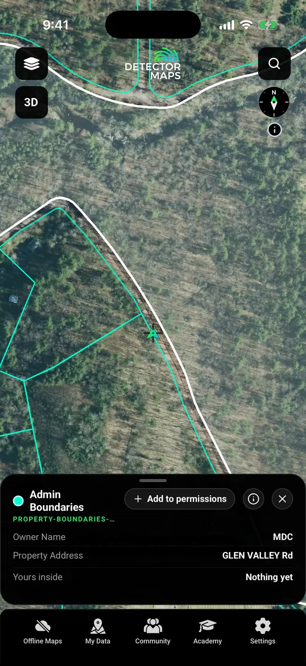
Tap a parcel to see who owns it. Land permissions keep each landowner’s details, gates and rules together.

  • Property boundaries with landowner names Pro
  • Land permissions: landowner contacts, parking and gate pins, rules and agreement photos. Tapping a parcel to start one needs Pro.
Property Boundaries over satellite with a tapped parcel card owned by a public agency (MDC, the Metropolitan District Commission), with the Add to permissions button

Property boundary. Pro.

05No reception

Download it on Wi-Fi. Use it with no signal.

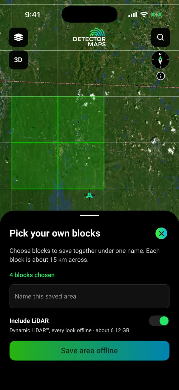
Pick the blocks you need and save them with your layers. Your records, search and waypoints keep working with no reception.

  • Offline maps for the areas you choose Explorer
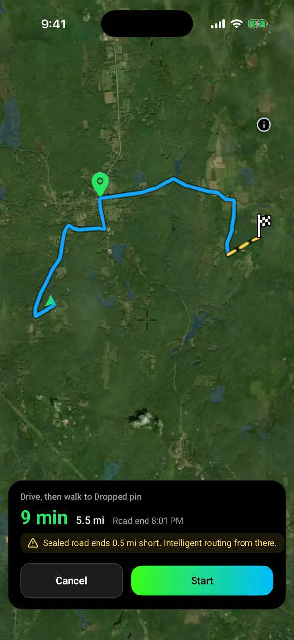
  • Go to: drive on paved roads with voice, then walk the last part Explorer
  • Trails, replay and backups Free
  • Apple CarPlay and Android Auto, with your layers
Offline block picker over central Massachusetts (Quabbin and Petersham area): 4 blocks chosen, Include LiDAR switch on, Dynamic LiDAR every look offline about 6.12 GB

Pick your blocks. Save with your layers.

Go to route, drive then walk: 9 min and 5.5 mi by road, then the sealed road ends 0.5 mi short and intelligent routing takes over (dashed yellow) to a dropped pin in central Massachusetts woodland

Drive, then walk. Voice on the road.

Seen enough?

Download free and open the field on your phone.

On iPhone? Get it on the App StoreOn Android? Get it on Google Play

Free to download on iPhone and Android.

7-day free trial on yearly plans · Nothing charged until it ends · Cancel anytime.

Start free trialOpen the web map

On your phone: App Store · Google Play

7-day free trial on yearly plans · Nothing charged until it ends · Cancel anytime.

Plans

Start free. Upgrade when the map earns it.

FreeForever

Try the map properly.

  • Ghost towns
  • Old USGS topo maps by era
  • One free area of 250 km² where every layer works except LiDAR
  • Trails, replay and backups
  • Waypoints, shapes and search
ExplorerMost popular

Get on the ground.

$59.99 a year Save 37%or $7.99 a monthabout 16c a day

7-day free trial on the yearly plan.

  • Homesteads, mills, ferries, schools, railroads, historic mine locations, the public land survey grid
  • Offline maps
  • Go to
  • Google satellite base map
  • Location sharing
Pro

The full toolkit, unlocked.

$99.99 a year Save 30%or $11.99 a month

7-day free trial on the yearly plan.

  • Everything in Explorer
  • Dynamic LiDAR and Terrain+ 3D models
  • Property boundaries with landowner names
  • Starting a land permission from a parcel

Prices are in US dollars.

On iPhone? Get it on the App StoreOn Android? Get it on Google Play

Free to download on iPhone and Android.

7-day free trial on yearly plans · Nothing charged until it ends · Cancel anytime.

Start free trialOpen the web map

On your phone: App Store · Google Play

7-day free trial on yearly plans · Nothing charged until it ends · Cancel anytime.

Not sure which plan? Start free. You can cancel in the app, under Settings, then Subscription.

Straight answers

Before you download.

What does it cost? Am I stuck?

Free is free forever. Paid plans start with a 7-day free trial on yearly plans. A card is taken up front, but nothing is charged until the trial ends. Cancel in the app under Settings, then Subscription. Cancel before the trial ends and you pay nothing. Notifications on? We remind you on day 5. Explorer $59.99 a year or $7.99 a month.

Isn’t this free government data?

The sources are public, and we name them on every layer. You get the work: merging them into one map, keeping them current, tiling them for offline and drawing every place the same way. USGS, BLM, US Fish and Wildlife Service, US Forest Service.

Does it work offline?

Yes, for the areas you save. Download them on Wi-Fi with your layers. GPS works without reception. Saving new areas needs Explorer. Your free area is saved offline on the Free plan. Dynamic LiDAR saves with your areas on Pro.

Are my spots private?

Private by default. Waypoints, Trails and finds are visible to your account only. Nothing goes to the Community unless you post it. Location sharing runs only in a session you start. Backups go to your own iCloud Drive or Google Drive.

Can I go there? Land access and legality

A mapped boundary alone does not tell you whether detecting is permitted. Laws vary by state, county and land manager. Permission is yours to get. Battlefield layers are reference only. Protected sites are off limits.

Does it cover my area?

Check your place in the Library before you download. One nationwide map.

I’m a beginner. Is it too much?

Start with the free layers. Tap any record to read what it is. Every layer has an (i) that says what it shows and where it falls short. Five short in-app lessons walk you through the map.

Will it flatten my battery?

Offline mode and a battery-saver GPS mode are built for a full day in the field on most modern phones.

Questions

Questions, answered.

Does it work with no signal?

Yes, for the areas you save. Download them on Wi-Fi before you go, with your layers. Your phone’s GPS works without reception, so the map, your records and your waypoints keep working. Saving new areas needs Explorer. Your one free area is saved offline on the Free plan.

What does it cost, and how does the trial work?

Free is free forever. Explorer is $59.99 a year or $7.99 a month. Pro is $99.99 a year or $11.99 a month. Yearly plans start with a 7-day free trial. A card is taken up front, but nothing is charged until the trial ends. Cancel before then and you pay nothing. Notifications on? We remind you on day 5.

Is detecting legal where I want to go?

Laws vary by state, county and land manager. Permission is your responsibility. Property boundaries show who owns a parcel. Detector Maps never gives permission.

Can I detect on the battlefields shown in the app?

No. Battlefield layers are for reference only, and protected sites are off limits.

What is free?

Ghost towns, old USGS topo maps by era, waypoints, Trails, backups and one free area of 250 km² (LiDAR not included).

Will the app tell me where to dig?

No. It gives you research: old towns, old maps, survey records and LiDAR. Where to dig, and whether you have permission, is your call.

What is Dynamic LiDAR, and who needs Pro?

It draws USGS 1 m bare-earth LiDAR on your phone in nine looks. In the USA it is a Pro feature, and the map stays clear where the USGS has no 1 m lidar.

Real data, named sources.

US Geological SurveyBureau of Land ManagementUS Fish and Wildlife ServiceUS Forest Service
Get Detector Maps

Plan the hunt before you drive.

Download free and lay an old map over the ground you plan to walk.

On iPhone? Get it on the App StoreOn Android? Get it on Google Play

Free to download on iPhone and Android.

7-day free trial on yearly plans · Nothing charged until it ends · Cancel anytime.

Scan with your phone camera to get the app
Start free trialOpen the web map

On your phone: App Store · Google Play

7-day free trial on yearly plans · Nothing charged until it ends · Cancel anytime.

Or open the web map

The Detector Maps support inbox is staffed by Matt and Tom, the two brothers who built it. Contact us