For detectorists in the UK

Know the field before you knock.

Recorded finds. Old Ordnance Survey maps. LiDAR for earthworks. Weekly field conditions. For England, Scotland and Wales.

  • Land permissions
  • what3words

On iPhone? Get it on the App StoreOn Android? Get it on Google Play

Free to download on iPhone and Android.

7-day free trial on yearly plans · Nothing charged until it ends · Cancel anytime.

Scan with your phone camera to get the app
Start free trialOpen the web map

On your phone: App Store · Google Play

7-day free trial on yearly plans · Nothing charged until it ends · Cancel anytime.

4.7 / 5 from 2,400+ ratings on the App Store and Google Play · 10,000+ prospectors and detectorists
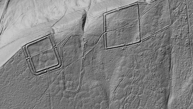
Dynamic LiDAR™ in England, drawn over satellite imageryDynamic LiDAR · any paid planCawthorn Roman camps© Mapbox, © Maxar
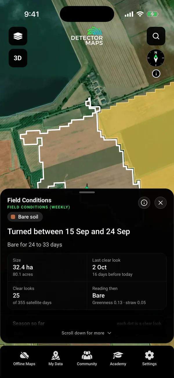
Field Conditions: a tapped 32 ha field in Lincolnshire, coloured by weekly Sentinel-2 state (bare soil, turned 15 to 24 Sep), with size, last clear look and clear looks count
Field Conditions · Explorer

Dynamic LiDAR over Roman camps, North Yorkshire. Satellite imagery © Mapbox, © Maxar. Layer data from the sources named on each card.

4.7 / 5from 2,400+ ratings on the App Store and Google Play
10,000+prospectors and detectorists
3 nationsEngland, Scotland and Wales
Weeklyevery farm field coloured from satellite
Free first

Free on every plan, forever.

Start with the free layers. Pay only if the map earns it.

  • Recorded finds, England and Wales
  • Historic footpaths and Roman roads, Scotland
  • what3words
  • One free area of 250 km², offline too
  • Trails, replay and backups

Inside your free area every layer works except LiDAR.

01The night before

Find where finds turned up.

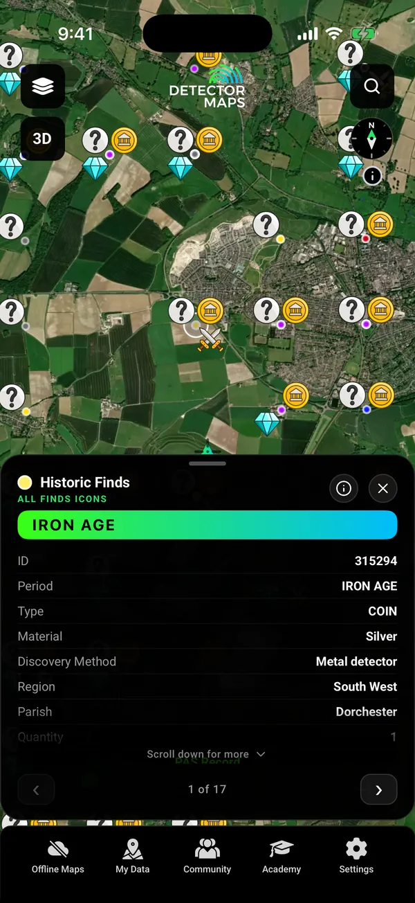
Recorded finds are plotted by period and free in England and Wales. Tap one to read its record. Find-spots are shown as 1 km squares, not exact coordinates, and the cards show no finder names.

  • All recorded finds Free
  • Finds by period and Coflein historic sites in Wales Explorer
Recorded finds (Portable Antiquities records) around Dorchester and Maiden Castle, icons dotted by period, with a tapped Iron Age silver coin card (1 of 17 nearby)

Recorded finds. 1 km squares.

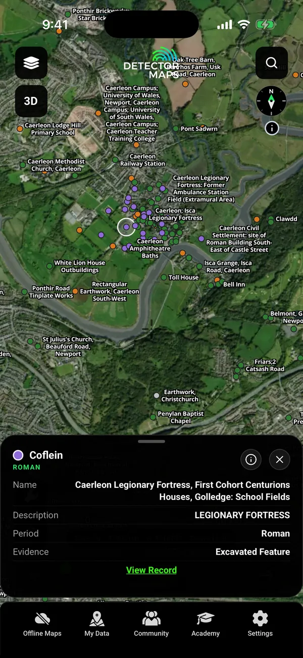
Coflein historic sites (Roman, Medieval, Iron Age, Bronze Age) around Caerleon, Wales, with a tapped Roman record card: Caerleon Legionary Fortress, First Cohort Centurions Houses

Wales. Coflein historic sites.

02Old maps

Read the old Ordnance Survey maps.

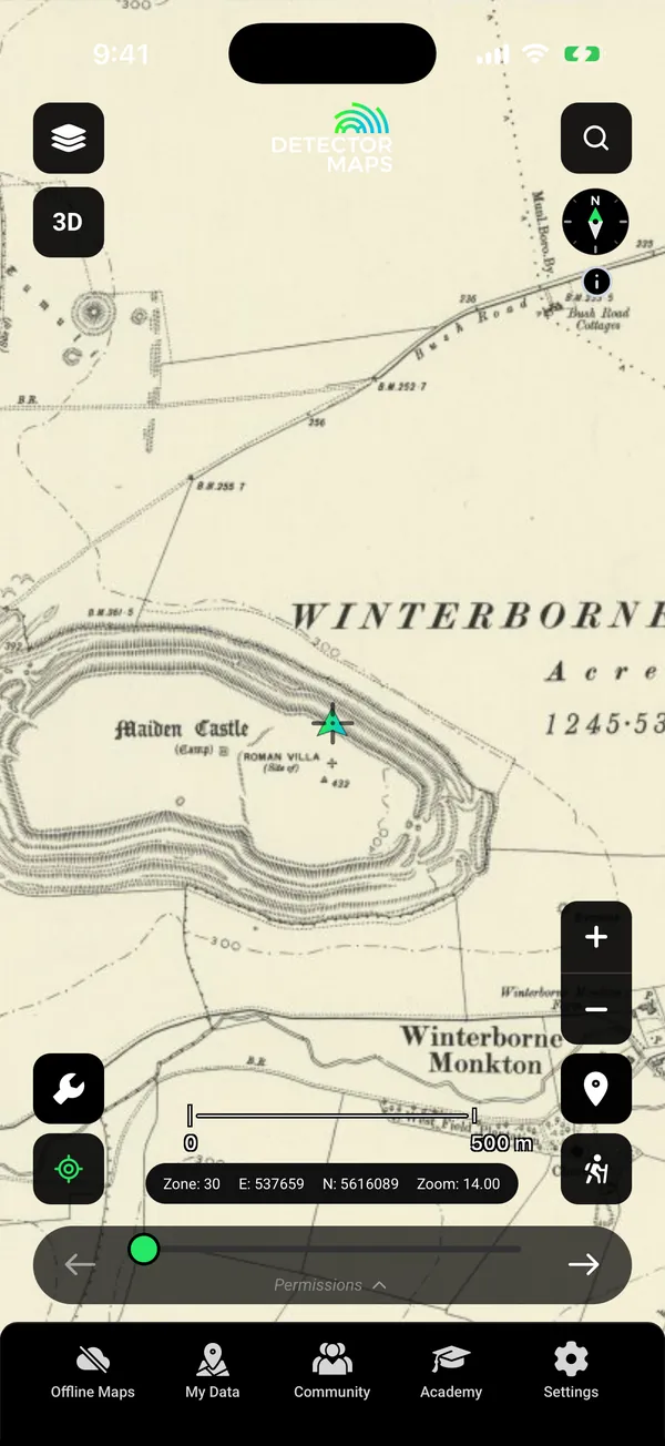
An old OS sheet shows what stood on the ground when it was drawn. Lay it over today’s map, with Roman roads and hillforts beside it.

  • Old OS maps (about 1888, about 1937, one-inch Hills, 1919 to 1947) Explorer
  • Roman roads and historic footpaths in Scotland Free
Old Ordnance Survey 1:10k map (circa 1888) over Maiden Castle hillfort, Dorset, with the site of a Roman villa and Winterborne Monkton

OS, about 1888. Maiden Castle.

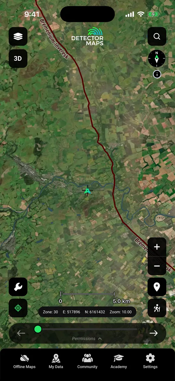
Roman Roads layer over farmland in the Scottish Borders: the dark red line is the Roman road labelled Bremenium to Inveresk

Scotland. Roman roads, free.

03See the earthworks

Dynamic LiDAR draws the ground as it is.

Ramparts, banks and field boundaries stand out in LiDAR. Change the look on your phone to bring out smaller earthworks. It shows the ground surface the lidar measured, not what lies beneath it.

  • Dynamic LiDAR in England and Scotland Any paid plan
  • Wales: on the web map now, phone app in the next update
  • Terrain+ in England can mark Earthworks, Roman Camp, Coin Hoard setting and Settlement on the 3D model. Those marks are leads, not finds. Any paid plan
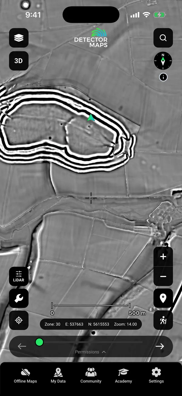
Dynamic LiDAR (Multi-scale, grey) over Maiden Castle hillfort, Dorset: ramparts, field boundaries and a Roman temple area, no card open

Maiden Castle. Multi-scale look.

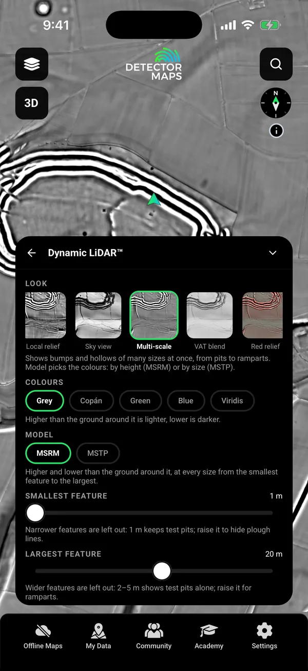
Dynamic LiDAR (Multi-scale, grey) over Maiden Castle hillfort, Dorset, with the Look card showing looks with live previews of this exact ground

Look card. Nine looks.

04Pick the right field

Field Conditions, every week.

Every farm field is coloured each week from satellite images: freshly turned, bare soil, stubble, stubble greening, new crop up, or crop or grass. Tap a field to read its season. Cloud can hide a field for weeks, so check its last clear look.

On the field card“It shows the ground, not permission to detect: ask the landowner first.”
  • Field Conditions in England, Scotland and Wales Explorer
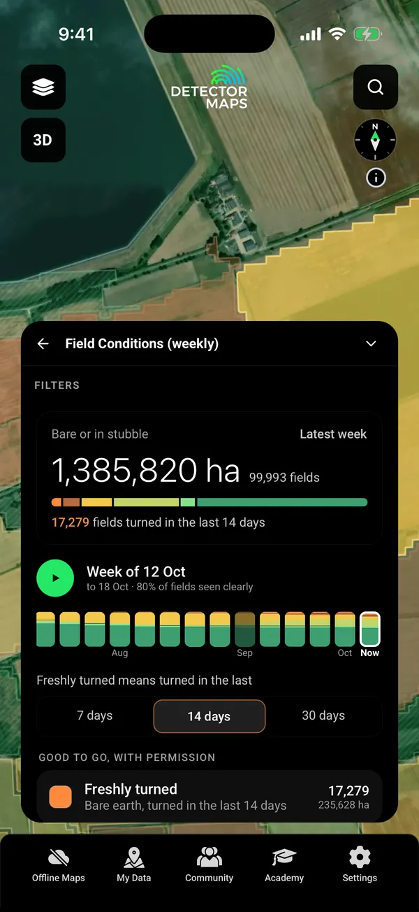
Field Conditions filter card: totals for bare or stubble ground, the scrolling week strip with Play, and the Freshly turned window (7, 14 or 30 days)

Week strip. Play it back.

Field Conditions: a tapped 32 ha field in Lincolnshire, coloured by weekly Sentinel-2 state (bare soil, turned 15 to 24 Sep), with size, last clear look and clear looks count

A field. Last clear look.

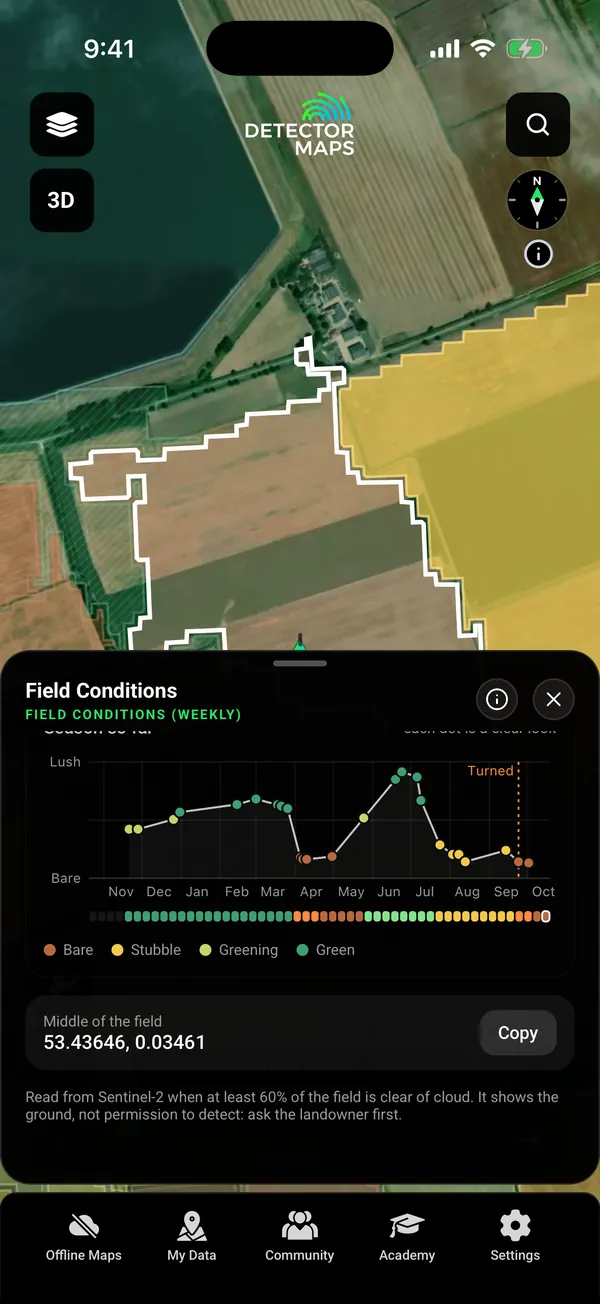
Field Conditions card scrolled to the season chart: one year of the field's state, from lush crop through stubble, to bare after turning, with the ask-the-landowner-first note

Season chart. One year.

05Keep the permission

Land permissions, kept together.

Turn a field into a permission: landowner contacts with Call, Text and Email, parking and gate pins, rules, agreement photos, and the finds and Trails inside it. Share a permission pack as a file.

  • Land permissions (starting one from a property boundary needs any paid plan) Any paid plan
  • what3words in search and on held points Free
06Read the crops

Dynamic NDVI reads the crop from above.

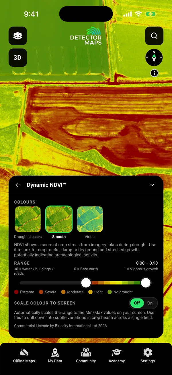
NDVI colours every field by how green and strong the plants are. Crop and parch marks can follow buried ditches and walls. Season, crop and moisture make similar patterns, so check them against the LiDAR and old maps.

  • Dynamic NDVI in England Add-on, +£50 a year
Dynamic NDVI over Dorset farmland south of Dorchester, with its card open: three colourings (Drought classes, Smooth, Viridis), a 0.00 to 0.90 range slider, the drought key and the Scale colour to screen switch

Dynamic NDVI. Add-on.

07No reception

Download it on Wi-Fi. Use it with no signal.

Pick the blocks you need and save them with your layers. Your records, search and waypoints keep working with no reception.

  • Offline maps for the areas you choose Explorer
  • Go to: drive on roads with voice, then walk the last part Explorer
  • Trails, replay and backups Free
  • Apple CarPlay and Android Auto, with your layers
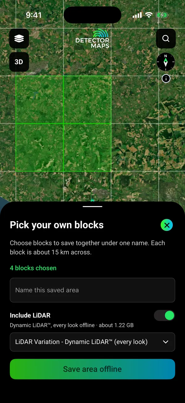
Offline block picker over Dorset farmland north-west of Dorchester, England: 4 blocks chosen, Include LiDAR switch on with the LiDAR Variation - Dynamic LiDAR (every look) choice, about 1.22 GB

Pick your blocks. Save with your layers.

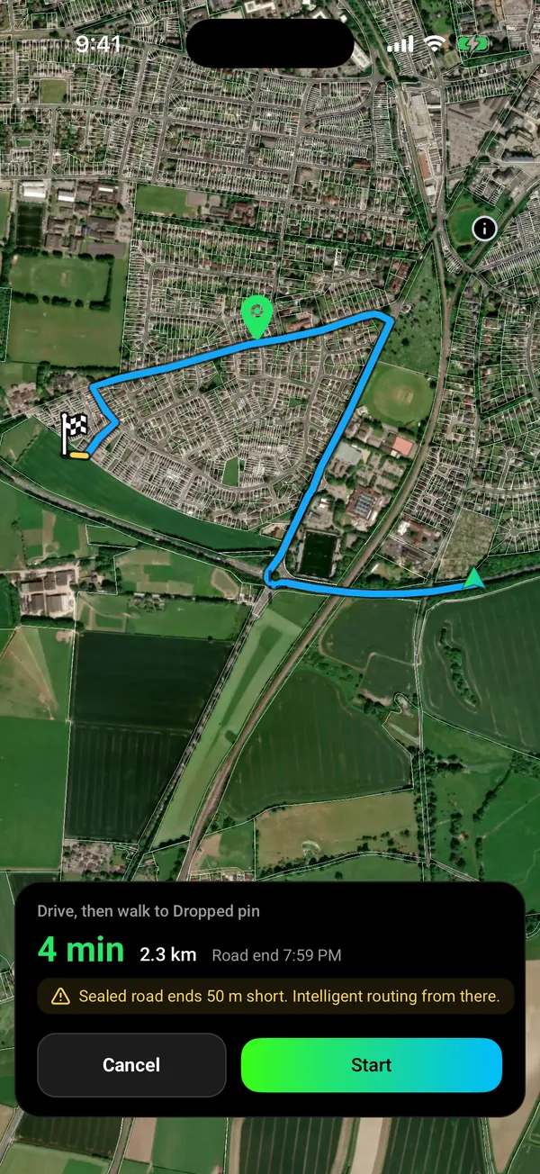
Go to route, drive then walk: 4 min and 2.3 km by road, then the sealed road ends 50 m short and intelligent routing takes over (yellow) to a dropped pin on the edge of a field in Dorchester

Drive, then walk. Voice on the road.

08On your computer too

Plan on the big screen.

Open app.detectormaps.com in your browser and sign in with the same account. One plan covers your phone and the web.

  • The same layers on a bigger map
  • Waypoints and Trails you sync from your phone
  • Plan at home, then save the area to your phone for no signal
  • Dynamic LiDAR for England, Scotland and Wales Any paid plan
  • Terrain+ 3D models Any paid plan

Open the web map

Seen enough?

Download free and open the field on your phone.

On iPhone? Get it on the App StoreOn Android? Get it on Google Play

Free to download on iPhone and Android.

7-day free trial on yearly plans · Nothing charged until it ends · Cancel anytime.

Start free trialOpen the web map

On your phone: App Store · Google Play

7-day free trial on yearly plans · Nothing charged until it ends · Cancel anytime.

Plans

Start free. Upgrade when the map earns it.

FreeForever

Try the map properly.

  • Recorded finds in England and Wales
  • Historic footpaths and Roman roads in Scotland
  • what3words
  • One free area of 250 km² where every layer works except LiDAR
  • Trails, replay and backups
  • Waypoints, shapes and search
ExplorerMost popular

Everything most detectorists need.

£50 a yearor £10 a month, including 20% VAT

7-day free trial on the yearly plan.

  • Old OS maps
  • Field Conditions
  • Dynamic LiDAR in England and Scotland
  • Terrain+ with England’s earthwork detectors
  • Property boundaries and land permissions
  • Offline maps
  • Go to
  • Google satellite base map
  • Location sharing

Add-on Dynamic NDVI, England only: +£50 a year.

The UK has Free and Explorer. There is no Pro plan.

On iPhone? Get it on the App StoreOn Android? Get it on Google Play

Free to download on iPhone and Android.

7-day free trial on yearly plans · Nothing charged until it ends · Cancel anytime.

Start free trialOpen the web map

On your phone: App Store · Google Play

7-day free trial on yearly plans · Nothing charged until it ends · Cancel anytime.

Not sure which plan? Start free. You can cancel in the app, under Settings, then Subscription.

Straight answers

Before you download.

What does it cost? Am I stuck?

Free is free forever. Paid plans start with a 7-day free trial on yearly plans. A card is taken up front, but nothing is charged until the trial ends. Cancel in the app under Settings, then Subscription. Cancel before the trial ends and you pay nothing. Notifications on? We remind you on day 5. Explorer £50 a year or £10 a month, including 20% VAT.

Isn’t this free government data?

The sources are public, and we name them on every layer. You get the work: merging them into one map, keeping them current, tiling them for offline and drawing every place the same way. Recorded finds, Environment Agency LiDAR, Sentinel-2.

Does it work offline?

Yes, for the areas you save. Download them on Wi-Fi with your layers. GPS works without reception. Saving new areas needs Explorer. Your free area is saved offline on the Free plan. Dynamic LiDAR saves with your areas.

Are my spots private?

Private by default. Waypoints, Trails and finds are visible to your account only. Nothing goes to the Community unless you post it. Location sharing runs only in a session you start. Backups go to your own iCloud Drive or Google Drive.

Can I go there? Land access and legality

A mapped boundary alone does not tell you whether detecting is permitted. Landowner permission is required before you detect anywhere in the UK. The map shows scheduled monuments and restricted areas and never gives permission.

Does it cover my area?

Check your place in the Library before you download. England, Scotland, Wales, each with its own rules.

I’m a beginner. Is it too much?

Start with the free layers. Tap any record to read what it is. Every layer has an (i) that says what it shows and where it falls short. Five short in-app lessons walk you through the map.

Will it flatten my battery?

Offline mode and a battery-saver GPS mode are built for a full day in the field on most modern phones.

Questions

Questions, answered.

Do I still need the landowner’s permission?

Yes, always. Landowner (and where relevant tenant) permission is required before you detect anywhere in the UK. Detector Maps helps you research the land and shows restricted areas, but it does not give you access. Get permission in writing and agree a finds arrangement beforehand.

What does it cost, and how does the trial work?

Free is free forever. Explorer is £50 a year or £10 a month, including 20% VAT. Dynamic NDVI is an England-only add-on, +£50 a year. Yearly plans start with a 7-day free trial. A card is taken up front, but nothing is charged until the trial ends. Cancel before then and you pay nothing. Notifications on? We remind you on day 5.

Does it cover England, Scotland and Wales?

Yes, each with its own sources and rules. England and Wales have recorded finds free. Scotland has historic footpaths and Roman roads free, and no Portable Antiquities Scheme records. Dynamic LiDAR is in England and Scotland on the phone. Wales is on the web map now and comes to the phone app in the next update.

Where do the finds come from, and how exact are they?

From the Portable Antiquities Scheme’s recorded finds in England and Wales. Find-spots are shown as 1 km squares, not exact coordinates, and the record cards show no finder names.

What is Field Conditions?

Every farm field coloured each week from Sentinel-2 satellite images: freshly turned, bare soil, stubble, stubble greening, new crop up, or crop or grass. It shows the ground, not permission to detect. Cloud can hide a field for weeks, so check its last clear look.

Will it tell me where to find treasure?

No. It is a research tool, not a guarantee. Records show where finds were reported. Old maps show what stood there. LiDAR shows the shape of the ground.

Does it work with no signal?

Yes, for the areas you save. Download them on Wi-Fi before you go, with your layers. Your phone’s GPS works without reception, so the map, your records and your waypoints keep working. Saving new areas needs Explorer. Your one free area is saved offline on the Free plan.

Can I use it on my computer?

Yes. Open app.detectormaps.com in your browser and sign in with the same account. Your plan works there too. So do the waypoints and Trails you sync from your phone. The web map needs a connection, so save areas in the phone app for places with no signal.

Real data, named sources.

Portable Antiquities SchemeEnvironment Agency LiDARCopernicus Sentinel-2Ordnance Survey maps
Get Detector Maps

Plan the next field tonight.

Download free, open this week’s field conditions and read the finds around you.

On iPhone? Get it on the App StoreOn Android? Get it on Google Play

Free to download on iPhone and Android.

7-day free trial on yearly plans · Nothing charged until it ends · Cancel anytime.

Scan with your phone camera to get the app
Start free trialOpen the web map

On your phone: App Store · Google Play

7-day free trial on yearly plans · Nothing charged until it ends · Cancel anytime.

Or open the web map

The Detector Maps support inbox is staffed by Matt and Tom, the two brothers who built it. Contact us